[ad_1]

An undersea volcano that erupted in mid-August off Japan, in the Pacific Ocean, poses risk to ships and planes. This was confirmed per reports of the National Aeronautics and Space Administration (NASA).
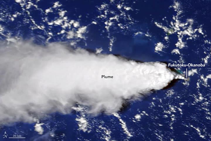
The Fukutoku-Okanoba volcano is about 25 meters below the sea and approximately 5kilometers north of the country’s South Iwo Jima Island. The volcano exploded on 13 August 2021. Following the explosion, a thick plume of smoke was observed in the sky.
This is unusual as eruptions from submarine volcanoes do not usually attain the height the plume did. On 14 August, Cloud-Aerosol Lidar with Orthogonal Polarization (CALIOP) sensor of NASA reported that the plume reached 16 kilometres from the surface.

Image Credits: NASA / earthobservatory.nasa.gov
The typical cruising altitude of any aircraft is approximately 10 kilometers. As a result, several Philippine Airlines flights that were to reach Japan were canceled.
Besides the aircraft, the volcano is a risk factor for ships. Satellite images have shown chunks of pumice floating in the sea after the explosion.
Pumice is one of the only rocks that can float on water. This is because of a combination of numerous cavities and air-filled holes in the rock.
NASA also added that pumice is hazardous for vessels. Besides scratching propellers and hulls, chunks of pumice floating in the water could also clog the engines and cooling systems, causing extensive damage.
NASA has also added that the aviation and marine warning mechanism for remote submarine volcanoes were being developed. Deploying cutting-edge data from satellites with surface observations offers the best chance to respond promptly.
Reference: downtoearth.org.in
Ash Plume From Volcano Eruption Hinders Satellite Imagery For Marine Navigation appeared first on Marine Insight – The Maritime Industry Guide
[ad_2]
This article has been posted as is from Source